Saturday, May 7, 2011

Lake Superior Lightning and the Spirit Tree


I was going through some older shots again last night and came across this one that I wanted to share. One of the "dream" shots that I want to get someday is a huge lightning bolt filling the sky behind the spirit tree. So far that hasn't happened, despite many tries. Whenever there is a thunderstorm heading our way that looks favorable, I head down to the tree hoping to catch that dream shot. While I haven't yet captured the giant sky-filling bolt behind the tree, I have captured some smaller ones that are quite interesting in their own right.


This is one such shot from back in June of . This particular storm was moving very slowly and as the storm hit Hat Point in Grand Portage, it changed course and headed out over the lake. This meant that I was able to photograph the lightning and the tree with minimal risk of getting wet from rainfall. I did feel a few drops here and there, but most of the storm was out over the lake so I stayed pretty dry. Most of the lightning was "heat lightning", which just flashes up in the clouds, but there were a few bolts as well. This was the best picture of a bolt that I captured that night.

Friday, May 6, 2011

The ONE quiver ski?

Does it exist? Orisit justthat your available terrain and skiingis limited?


If it does exist what is the single ski ?


Or is it simply the Indian and not the arrow?


I generally owned several pairs of alpine skis when I worked at a ski area. But also generally only skied one pair the majority of the time.Rock skis maybe early season. Beaters they you didn't mind trashing and a decent pair of skis for the rest of the time. When I got a chance to do some heli skiing it didn't take long to figure out most of the guides were on shorterEuro mountaineering skis. Easier to ski in the always changing conditions. But theywere hard to obtain in the early '80s here in the US. That was my introduction into a 2nd pair of skis or the start of a quiver. I thought it more the "right tool" for the job.

I started using the short mountaineering skis for early morning bomb runs and avi control work. They made the work a lot easier. By mid morning I would usually change back to my long boards and enjoy the groomers.

Today on any given day in the winter or springI might ski groomed, face shot powder off piste, 10K vertical gain by foot for a 11K dropor a steep corn gully I have to hike into and maybe hike out of as well when I amdone.

To be honest I ski much more terrain and different snow conditions now than I did guiding and skiing12 months of the year in the distant past. Strange as that might sound.

Different skis for every occasion seems like a good thing :)I have one or two that are good for most things. But nothing I would like to be on every where I am willing to ski now.

But if you have that magical ski you take every where I would love to hear about it!!


Wednesday, May 4, 2011

Rutland Round 2 - Uppingham to Seaton


With Marta - 10 miles in warm dry weather, though the path near Eyebrook reservoir was muddy. Lunch at Lyddington.


We set off from Uppingham, walking along the Stockerston Road out of the town and taking this footpath to the right. It starts from a sort of lay-by on a bend in the road.


The sign's a bit hidden, but the map and instructions are clear here.

For the first time in quite a while we saw lots of tortoiseshell butterflies on the thistle flowers.


The path is clearly marked as it goes through the fields and along the ridge, past a building marked on the map as a meteorological station, and along to Kings Hill Lodge farm, where it turns left to join the Stockerston Road again.


Views towards Wardley Wood


At the road we turned left and after a hundred yards or so, opposite some houses, we turned right along a bridleway towards Stoke Dry Wood. This goes up to the entrance to the wood, and continues just outside, so that we kept the wood edge on our right.


View of Eyebrook from corner of Stoke Wood


The path continues round the wood, with the occasional waymarker. A footpath crossed our route and led into the wood - ignore this one. The track turns left, then in while right keeping to the high ground, eventually coming out by Manor Farm at the top of the hill in Stoke Dry. Here we turned right and walked downhill to the church.


St Andrews church,Stoke Dry with the window to the priest's room over the porch


Steps up to the parvise or priest's room -rumours about conspirators of the gunpowder plot using the room seem to be without foundation, and the story that a local witch was imprisoned and starved in here are also unconfirmed.


Martyrdom of St Edmund. The painting shows men wearing feather headdresses shooting bows and arrows, and has been taken to support the theory that the Vikings discovered North America two centuries before Columbus.

For more discussion of this see this article.

After the church we walked down the hill and took the footpath to the left just before the entrance to the woodland around Eyebrook reservoir. The path hugs the fence, and was pretty muddy on this occasion.


Snack break by the water

After the entrance gate to the Eyebrook area the path heads diagonally up hill through a field. There are great views of the water to the west from the gate in the opposite corner, and Stoke Dry can be seen in the distance to the north west.


Looking back towards Eye Brook Reservoir


Stoke Dry church behind us


The reservoir again

The route now takes us down to the A6003. We managed to miss a slight turn to the left at the top of this section, but our mistake soon became obvious. At the road we turned right - the verge is fairly wide, and the road walk is only for a couple of hundred yards.


The path turns left at the tarmac road to a gas pressure control station on the other side of the road. A stile took us on to the path - mud again just here, and cows who did little more than lazily raise their heads and watch us.


We followed the yellow-painted post waymarkers over stiles and fields. There's a footbride into another field, which we crossed diagonally. After whiles and stiles we headed fro the farm buildings, and followed the waymarks to reach the road and turned left into Lyddington. Lovely lunch in the Old White Hart's garden before setting off on the final couple of miles.


Art in Lyddington

We crossed the village green and followed the track to a stile. The path goes along the left-hand hedge and leads to a gateway on the left. In this field are the traces of the fishponds which were once used by the bishop's palace (the Bede House).


The medieval fishponds of Lyddington


One of mine

The path goes through the gateway and into a narrow field. We walked along this and over another stile. Then we turned right and followed the path straight up the hill. We continued to the end of field, then turned right and almost immediately left, walking with a ditch on the left and continuing until we reached the farm track by Grange farm. This leads up the hill and into Seaton, with glimpses of the Welland Valley viaduct to the right.


Yellowstone :: Grand Prismatic Spring

Wednesday, August 31st - - Upon leaving the West Thumb area I stopped to see Old Faithful. I waited a little over half an hour for the old fellow to erupt. I'll just say it was less than spectacular. Old Faithful can have eruptions that last from a minute and a half to over four minutes. I happened to be there during one of the short eruptions in which it does not reach its maximum height. The next eruption, 90 minutes later, would probably have been a long one but I decided to go on to the next site on my list of “must see” things.


This diagram shows the features within the Midway Geyser Basin, the largest of which is the colorful Grand Prismatic Spring.


The water from the springs and pools in the area eventually makes its way to the Firehole River flowing below. Even here you could feel the heat from the water as it passed by. The sulfur smell was quite strong also.


A boardwalk trail meanders through the area giving you an “up close” look at the pools and springs. This is at the lower edge of Excelsior Geyser, which is currently dormant.


A panoramic view of Excelsior Geyser from its northern side (as with all photos, double-click on the image to view a larger version). Water flows from the geyser pool, down the hill, and into the Firehole River.


Water from the Grand Prismatic Spring flows into the Excelsior Geyser.


A view of Excelsior Geyser from its southwestern side.


Looking to the west toward the boardwalk around Grand Prismatic Spring from the boardwalk on the west side of Excelsior Geyser. The water is only a few inches deep between the two features.


The Grand Prismatic Spring. Colorful tendrils are formed by the heat-loving microorganisms where the water flows over the edge of the spring.


Looking back toward Excelsior Geyser.


The Opal Pool. You can just barely see Firehole River in the upper center of the photograph and the mountains way off in the far distance.


It was late in the evening when I headed back to the campground. This photo was taken along the western side of the southern loop in part of the Hayden Valley – that's the Yellowstone River flowing through the valley.


It had been a great day despite a few quick moving rain showers. The temperature was in the upper 60s and lower 70s all afternoon – great weather for sightseeing and playing the tourist!


Tuesday, May 3, 2011

Where I Was

May 1979. I can still feel the freezing cold of the water as I walked through the stream to the dunes. The warmth of the sun and the chill of the morning breeze. The quietness broken only by the occasional laughter and voices of other visitors. It was a time of change. One stage of life ending and another beginning. A return to civilian life after 9 1/2 years in the Navy.

I purchased a postcard at the gift shop that I still have posted on the bulletin board next to my computer. It included a few words written by Ann Zwinger ". . . even in winter there is the promise of spring. . . The white of snow becomes the white of summer clouds. . . part of each season is contained in every other."

Anyone care to venture a guess as to where this picture was taken? A little hint, western United States ;-)

Update May 21, .. 11:00 a.m
Craig Manson of Geneablogie fame has correctly identified the above scene as the Great Sand Dunes National Park & Preserve. Located in the southwest corner of Colorado, it is an amazing area. It's on my list of places to visit, again. Someday.

Some incredibly nice photographs:
http://www.nps.gov/archive/grsa/resources/photos_dunes.htm

Children's artwork inspired by the dunes:
http://www.nps.gov/archive/grsa/artwork.htm

Links to more photographs:
http://www.nps.gov/archive/grsa/resources/photos.htm

There are a lot of other nice websites, just do a search for Great Sand Dunes...

Sunday, May 1, 2011

Redefining "Shoe Tree"

Wednesday, October 13th - - Several times in southern Oregon I saw trees like this one - out in the middle of nowhere, miles from any town, with shoes strung through some branches and dangling from others. This “Shoe Tree” happened to be situated near a pull out so I could safely stop. It was about 50 miles east of Fallon, Nevada along U.S. 50 midway between the junctions of Nevada highways 361 and 372. Proclaimed on billboards in Austin and Eureka - the only towns in the 250-mile stretch of U.S. 50 between Fallon and Ely - as “the loneliest highway in America.”

The significance of it all? I haven't got a clue... but it sure is lotsa shoes! And, aside from the two towns, it was the most interesting thing along the way...


Intruder alert

Jasmine alerted us to the presence of an intruder last night in her usual manner (by barking like a crazy dog).


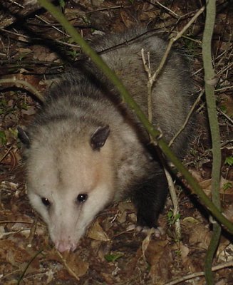
Just on the other side of the tree line we found a possum. A.k.a. a Virginia Opossum (Didelphis virginiana), a.k.a. North America's only native marsupial.

He didn't roll over and play dead, but he sure did a good job at playing frozen.